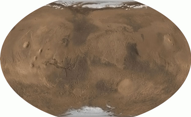
Explanation: From pole to pole, from east to west, this is all of Mars. The above picture was digitally reconstructed from over 200 million laser altimeter measurements taken by the Mars Global Surveyor spacecraft currently orbiting Mars. The image strips Mars of its clouds and dust, and renders the whole surface visible simultaneously in its true daytime color. Particularly notable are the volcanoes of the Tharsis province, visible on the left, which are taller than any mountains on Earth. Just to the left of center is Valles Marineris, a canyon much longer and deeper Earth's Grand Canyon. On the right, south of the center, is the Hellas Planitia, a basin over 2000 kilometers wide that was likely created by a collision with an asteroid. Mars has many smooth lowlands in the north, and many rough highlands in the south. Mars has just passed its closest approach to Earth since 1988 and can be seen shining brightly in the evening sky.
1999 2000 2001 2002 2003 2004 2005 2006 2007 2008 2009 2010 2011 2012 2013 2014 2015 2016 2017 2018 2019 2020 2021 2022 2023 2024 2025 2026 |
Январь Февраль Март Апрель Май Июнь Июль Август Сентябрь Октябрь Ноябрь Декабрь |
NASA Web Site Statements, Warnings, and Disclaimers
NASA Official: Jay Norris. Specific rights apply.
A service of: LHEA at NASA / GSFC
& Michigan Tech. U.
|
Публикации с ключевыми словами:
map - surface - Mars - Марс - поверхность Марса - карты планет
Публикации со словами: map - surface - Mars - Марс - поверхность Марса - карты планет | |
См. также:
Все публикации на ту же тему >> | |
