|
|
Keyword: Mars polar lander
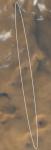 Mars Polar Lander Target Ellipse
4.12.1999
South is up in this recent composite color picture of Mars Polar Lander's target region near the Martian South Pole taken on November 28. Imaged by the orbiting Mars Global Surveyor's wide angle camera, the area covered is 105 kilometers across with the expected landing ellipse superposed.
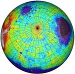 Southern Mars
3.12.1999
This topographical map of the southern hemisphere of Mars was generated using data from the Mars Orbiter Laser Altimeter (MOLA). Flying on the Mars Global Surveyor spacecraft, MOLA has bounced a laser beam off the Martian surface over 200,000,000 times producing a wealth of detailed elevation measurements.
|
January February |
|||||||||||||||||||||||||||||||||||||||||||||||||