|
|
Keyword: hurricane
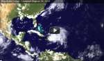
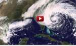 Superstorm Sandy From Formation to Landfall
7.11.2012
It was the largest hurricane ever recorded in the Atlantic Ocean. The cost of its devastation is still unknown. Pictured above is a movie of Superstorm Sandy taken by the Earth-orbiting GOES-13 satellite over...
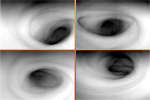 Venus South Polar Vortex
28.09.2010
What's happening over the South Pole of Venus? To find out, scientists have been studying images taken by the robotic Venus Express spacecraft when it passes over the lower spin axis of Earth's overheated twin.
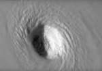 Swirling Around the Eye of Hurricane Irma
10.09.2017
Why does a hurricane have an eye at its center? No one is yet sure. What happens in and around a hurricane's eye is well documented, though. Warm air rises around the eye's edges, cools, swirls, and spreads out over the large storm, sinking primarily at the far edges.
 Hurricane Season Animated
27.11.2017
Where do hurricanes go? To better understand dangerous storms, NASA compiled data from several satellites into a supercomputer simulation of this past year's hurricane season. Specifically, the featured video shows how smoke (white), sea salt (blue), and dust (brown) tracked from 2017 August through October across the northern half of Earth's Western Hemisphere.
 Hurricane Harvey Strengthens
26.08.2017
A large and dangerous hurricane has developed in the Gulf of Mexico. The featured time-lapse video shows Hurricane Harvey growing to Category 4 strength over the past few days, as captured by NASA and NOAA's GOES-East satellite.
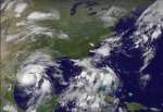
 Hurricane Irene Forms
27.08.2011
How does a hurricane form? Although a complete picture is still being researched, insight into this process might be gleaned by watching the above time lapse movie of the formation of Hurricane Irene, a large storm system currently threatening the eastern seaboard of the USA.
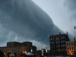 Roll Cloud Over Wisconsin
31.08.2011
What kind of cloud is this? A type of arcus cloud called a roll cloud. These rare long clouds may form near advancing cold fronts. In particular, a downdraft from an advancing storm front can cause moist warm air to rise, cool below its dew point, and so form a cloud.
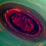 Saturn Hurricane
2.05.2013
Acquiring its first sunlit views of far northern Saturn late last year, the Cassini spacecraft's narrow-angle camera recorded this stunning image of the vortex at the ringed planet's north pole. The false...
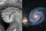 Logarithmic Spirals Isabel and M51
25.09.2003
Uncomfortably close hurricane Isabel (left) and 30 million light-year distant galaxy M51 actually don't have much in common. For starters, Isabel was hundreds of miles across, while M51 (the Whirlpool Galaxy) spans about...
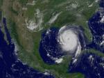 Hurricane Katrina in the Gulf of Mexico
29.08.2005
Where will Hurricane Katrina go? One of the stronger storm systems of modern times appears headed for landfall somewhere in the southern USA sometime today. Katrina was designated yesterday a rare Category 5 Hurricane, the strongest designation for a storm on Earth, and one that indicates sustained winds greater than 250 kilometers per hour.
|
January February March April May June July |
|||||||||||||||||||||||||||||||||||||||||||||||||