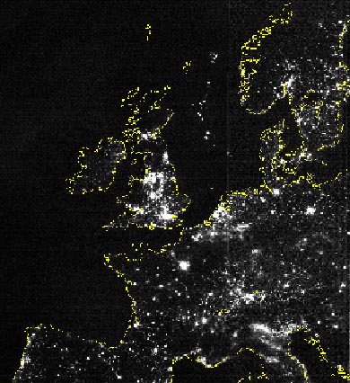
Explanation: This is what Europe looks like at night! Can you find your favorite European city? Although not all of Europe is shown, city lights might make this task possible. Continental outlines have been artificially drawn in yellow. The above picture is actually a composite of over 200 images made by satellites orbiting the Earth. Scans were made by the USAF Defense Meteorological Satellite Program (DMSP) Operational Linescan System. The DMSP satellites continue to help in the understanding and prediction of weather phenomena as well as provide key information about population patterns, city light levels, and even rural forest fires.
1999 2000 2001 2002 2003 2004 2005 2006 2007 2008 2009 2010 2011 2012 2013 2014 2015 2016 2017 2018 2019 2020 2021 2022 2023 2024 2025 2026 |
Январь Февраль Март Апрель Май Июнь Июль Август Сентябрь Октябрь Ноябрь Декабрь |
NASA Web Site Statements, Warnings, and Disclaimers
NASA Official: Jay Norris. Specific rights apply.
A service of: LHEA at NASA / GSFC
& Michigan Tech. U.
|
Публикации с ключевыми словами:
Earth - Europe - Земля
Публикации со словами: Earth - Europe - Земля | |
См. также:
Все публикации на ту же тему >> | |
