|
|
You entered: topography
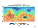 The Topography of Mars
28.06.2001
Mars has its ups and downs. Visible on the above interactive topographic map of the surface of Mars are giant volcanoes, deep valleys, impact craters, and terrain considered unusual and even mysterious. Particularly notable...
 A View from Venus: Rift Valley
24.06.1996
Color information from the Soviet Venera landers and radar data from the Magellan spacecraft were used to construct this striking perspective view of the Venusian landscape. (In this computer generated image, the vertical scale has been exagerated.) In the foreground is the edge of a rift valley created by faulting in the crust of Venus.
 Swiss Cheese Like Landscape on Mars
27.03.2001
Why do parts of the south pole of Mars look like swiss cheese? This little-understood landscape features flat-topped mesas nearly 4 meters high and circular indentations over 100 meters across. Since this swiss-cheese topography...
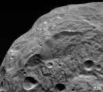 A Landslide on Asteroid Vesta
28.11.2011
Asteroid Vesta is home to some of the most impressive cliffs in the Solar System. Pictured above near the image center is a very deep cliff running about 20 kilometers from top to bottom. The image was taken by the robotic Dawn spacecraft that began orbiting the 500-kilometer space rock earlier this year.
 Big Blue Marble Earth
26.04.2003
This reconstructed digital portrait of our planet is reminiscent of the Apollo-era pictures of the "big blue marble" Earth from space. To create it, researchers at Goddard Space Flight Center's Laboratory for Atmospheres...
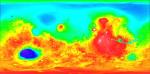 Topographical Mars
28.05.1999
Contrasting colors trace changing elevations in this new high-resolution topographic map of Mars. Just released, the data were gathered in 1998 and 1999 by the Mars Orbiter Laser Altimeter (MOLA) onboard the Mars Global Surveyor spacecraft.
 Blue Marble 2000
20.04.2000
This newly released digital portrait of our planet is reminiscent of the Apollo-era pictures of the "big blue marble" Earth from space. To create it, researchers at Goddard Space Flight Center's Laboratory...
APOD: 2026 April 22 ┴ Earthset with an iPhone
22.04.2026
What does it mean for the Earth to set? Artemis II Commander Reid Wiseman gave us another spectacular view of Earth from their historic flyby of the Moon. Commander Wiseman's video, taken with an iPhone at 8x zoom, shows our entire planet gradually blocked from view by the Moon.
|
January February March April May June |
|||||||||||||||||||||||||||||||||||||||||||||||||