|
|
You entered: laser altimeter
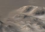
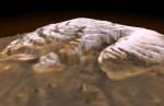 3-D Mars North Pole
16.12.1998
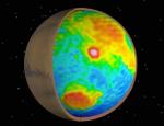
This dramatic premier three-dimensional visualization of Mars' north pole is based on elevation measurements made by an orbiting laser. During the Spring and Summer of 1998 the Mars Orbiter Laser Altimeter (MOLA) flashed laser pulses toward the Martian surface from the Global Surveyor spacecraft and recorded the time it took to detect the reflection.
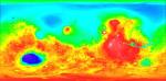
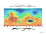 The Topography of Mars
28.06.2001
Mars has its ups and downs. Visible on the above interactive topographic map of the surface of Mars are giant volcanoes, deep valleys, impact craters, and terrain considered unusual and even mysterious. Particularly notable...
 APOD: 2024 July 24 Б Exaggerated Moon
24.07.2024
Our Moon doesn't really have craters this big. Earth's Moon, Luna, also doesn't naturally show this spikey texture, and its colors are more subtle. But this digital creation is based on reality.
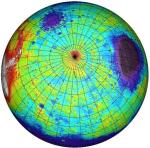 Southern Mars
3.12.1999
This topographical map of the southern hemisphere of Mars was generated using data from the Mars Orbiter Laser Altimeter (MOLA). Flying on the Mars Global Surveyor spacecraft, MOLA has bounced a laser beam off the Martian surface over 200,000,000 times producing a wealth of detailed elevation measurements.
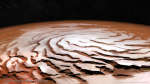 APOD: 2025 July 6 Б The Spiral North Pole of Mars
6.07.2025
Why is there a spiral around the North Pole of Mars? Each winter this pole develops a new outer layer about one meter thick composed of carbon dioxide frozen out of the thin Martian atmosphere. This fresh layer is deposited on a water-ice layer that exists year round.
 Frosty Mountains on Mars
30.07.2003
What causes the unusual white color on some Martian mountains? The answer can be guessed by noticing that the bright areas disappear as springtime takes hold in the south of Mars: dry ice. Unlike water ice, dry carbon dioxide ice sublimates directly to gas from its frozen state.
 Topographical Mars
28.05.1999
Contrasting colors trace changing elevations in this new high-resolution topographic map of Mars. Just released, the data were gathered in 1998 and 1999 by the Mars Orbiter Laser Altimeter (MOLA) onboard the Mars Global Surveyor spacecraft.
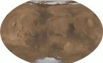 All of Mars
26.06.2001
From pole to pole, from east to west, this is all of Mars. The above picture was digitally reconstructed from over 200 million laser altimeter measurements taken by the Mars Global Surveyor spacecraft currently orbiting Mars.
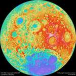 A Colorful Side of the Moon
18.11.2011
This colorful topographical map of the Moon is centered on the lunar farside, the side not seen from planet Earth. That view is available to the Lunar Reconnaissance Orbiter though, as the spacecraft's wide angle camera images almost the entire lunar surface every month.
 Inside Mars
23.03.2000
What's inside Mars? From orbit, the Mars Global Surveyor (MGS) spacecraft has recorded detailed images of the red planet since July 1997. Still, its cameras can not look beneath the surface. But minute...
|
January February March April May June |
|||||||||||||||||||||||||||||||||||||||||||||||||