|
|
You entered: Valles Marineris
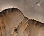 Mars: A Canyon's Edge
18.03.1998
High resolution Mars Global Surveyor images were combined with Viking Orbiter color data to produce this stunning, detailed view of a Martian canyon's edge. The area pictured is about 6 miles wide and represents a tiny part of the northern edge of the canyon Valles Marineris, whose total length is about 2,500 miles.
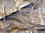
 Layers in Aureum Chaos
4.04.2008
At first glance these undulating shapes in shades of blue might look like waves on an ocean. Seen here in a false-color image from the Mars Reconnaissance Orbiter's HiRISE camera, they are actually layered rock outcrops found in Aureum Chaos.
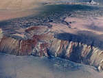
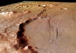 Crater Wall on Solis Planum
30.09.2004
This dramatic perspective view looks south-east along the wall of a large eroded impact crater on Solis Planum, bordering the mountainous Thaumasia region of Mars. Stretching for about 50 kilometers into the scene, the crater wall is around 800 meters high.
 Mars: A Journey's End
3.07.1997
Mars Pathfinder is nearing the end of its 7 month journey. The robot spacecraft is scheduled to use parachutes, rockets, and airbags to "bouncedown" on the red planet tomorrow - July 4th. This Hubble Space Telescope image of Mars was taken a few days ago to check on the weather.
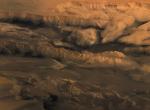 Melas, Candor, and Ophir: Valleys of Mariner
16.02.2005
First imaged by the Mariner 9 spacecraft, Valles Marineris, the grand canyon of Mars, is a system of enormous depressions or chasmas that stretch some 4,000 kilometers along the Martian equator. Looking north over the canyon's central regions, dark Melas Chasma lies in the foreground of this spectacular perspective view.
 APOD: 2007 February 20- White Ridges on Mars
19.02.2007
What created these white ridges on Mars? The images showing the white ridges, including some of the highest resolution images ever taken from Martian orbit, were recorded last year by the Mars Reconnaissance Orbiter (MRO).
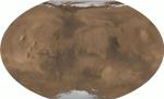 All of Mars
26.06.2001
From pole to pole, from east to west, this is all of Mars. The above picture was digitally reconstructed from over 200 million laser altimeter measurements taken by the Mars Global Surveyor spacecraft currently orbiting Mars.
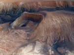 Collapse in Hebes Chasma on Mars
27.05.2017
What's happened in Hebes Chasma on Mars? Hebes Chasma is a depression just north of the enormous Valles Marineris canyon. Since the depression is unconnected to other surface features, it is unclear where the internal material went.
 APOD: 2025 July 15 Б Collapse in Hebes Chasma on Mars
14.07.2025
What's happened in Hebes Chasma on Mars? Hebes Chasma is a depression just north of the enormous Valles Marineris canyon. Since the depression is unconnected to other surface features, it is unclear where the internal material went.
 High Cliffs Surrounding Echus Chasma on Mars
23.07.2008
What created this great cliff on Mars? Did giant waterfalls once plummet through its grooves? With a four-kilometer drop, this high cliff surrounding Echus Chasma, near an impressive impact crater, was carved by either water or lava.
|
January February March April May |
|||||||||||||||||||||||||||||||||||||||||||||||||