|
|
Keywords: Antarctica, Earth, map
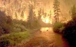
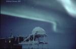 Aurora Over Antarctica
20.03.2002
Looking out from the bottom of the world, strange and spectacular sights are sometimes observed. Such was the case during the long Antarctic night of 1998, as awesome aurora sub-storms were photographed above scientific outposts. Visible in the left foreground of the above photograph is the Martin A.
 Antarctic Ice Shelf Vista
27.05.2002
It's all gone but the mountains. Most of the sprawling landscape of ice that lies between the mountains visible above has now disintegrated. The above picture was taken in Antarctica from the top of Grey Nunatak, one of three Seal Nunatak mountains that border the Larsen B Ice-Shelf.
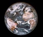 An Earth Ornament
25.12.1996
The Apollo 8 astronauts spent the 1968 Christmas Season in lunar orbit, returning with striking images of the Moon and Earth from space which inspired the world. While in lunar orbit...
30.08.2008
What would it be like to stand atop the tallest mountain on Earth? To see a full panoramic vista from there, scroll right. Visible are snow peaked mountains near and far, tremendous cliffs, distant plateaus, the tops of clouds, and a dark blue sky. Mt.
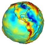 GRACE Maps the Gravity of Earth
23.07.2003
Why do some places on Earth have higher gravity than others? Sometimes the reason is unknown. To help better understand the Earth's surface, slight distance changes between a pair of identically orbiting satellites named GRACE have been used to create the best ever map of Earth's gravitational field.
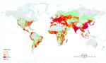 Where People Live on Planet Earth
5.03.2003
Where do people live on Planet Earth? Although people inhabit every continent, the highest population densities occur in Asia. Sparsely inhabited regions occur on virtually every continent, however, including the Sahara Desert in Africa...
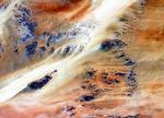 Terkezi Oasis in the Sahara Desert
12.11.2002
Dominating the top third of Africa is the largest band of dry land on Earth: the Sahara Desert. Stretching across the Sahara are vast planes of sand and gravel, seas of sand dunes, and barren rocky mountains.
 Fire on Earth
21.11.2000
Sometimes, regions of planet Earth can be seen lit up with fire. Since fire is the rapid acquisition of oxygen, and since oxygen is a key indicator of life, fire on any planet would be an indicator of life on that planet.
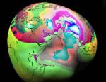 A Gravity Map of Earth
13.11.2001
Is gravity the same over the surface of the Earth? No -- it turns out that in some places you will feel slightly heavier than others. The above relief map shows in exaggerated highs and lows where the gravitational field of Earth is relatively strong and weak.
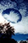 A Hole Punch Cloud Over Alabama
12.01.2004
What could create a huge hole the clouds? Such a hole, likely hundreds of meters across, was photographed last month from a driveway near Mobile, Alabama, USA. Very unusual to see, hole-punch clouds like this are still the topic of meteorological speculation. A leading hypothesis holds that the hole-punch cloud is caused by falling ice-crystals.
|
January February March April May |
|||||||||||||||||||||||||||||||||||||||||||||||||