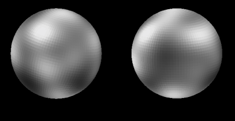
Hubble Telescope Maps Pluto

Explanation:
No spacecraft from Earth has
yet explored Pluto
but astronomers have found ways of
mapping its surface.
A stunning map of
this distant, diminutive planet, the first based on
direct images, was revealed late last week in a
Hubble Space Telescope press release.
Above are two opposite hemisphere views of
the computer constructed
map of Pluto's surface (north is up).
The grid pattern is due to the computer technique used
where each grid element is over 100 miles across.
The map is based on Hubble images made when
Pluto was a mere 3 billion miles distant.
It shows strong brightness variations -
confirming and substantially improving upon
ground based observations.
While the brightness variations may be due to surface features like craters
and basins they are more likely caused by regions of nitrogen
and methane frost.
The frost regions should show "seasonal" changes which can be
tracked in future Hubble observations.
Yes, Pluto is a planet
even though it is only 2/3 the size of Earth's Moon!
Information:
The
Scale of the Universe Debate in April 1996
Authors & editors:
Robert Nemiroff
(MTU) &
Jerry Bonnell
(USRA)
NASA Web Site Statements, Warnings,
and Disclaimers
NASA Official: Jay Norris.
Specific
rights apply.
A service of:
LHEA at
NASA /
GSFC
& Michigan Tech. U.

