Credit & Copyright: MOLA Science Team,
NASA
Explanation:
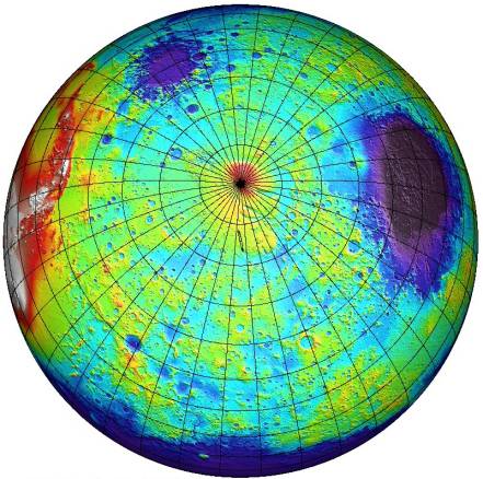
This topographical map of the southern hemisphere
of Mars was
generated using data from the
Mars Orbiter Laser Altimeter (MOLA).
Flying on the Mars Global Surveyor spacecraft, MOLA has
bounced a laser beam off the Martian surface over 200,000,000
times producing a wealth of detailed elevation measurements.
The
MOLA measurements have been color-coded so,
for example, the white areas at left
are the highest elevations in the southern
Tharsis region
and not snow-covered peaks.
These areas are more
than 6 kilometers above the hypothetical Martian "sea-level".
Likewise, deep blues and purples are not
water oceans but correspond
to the lowest elevations (more than 4 kilometers below "sea-level"),
like those found within the giant Hellas impact basin at right.
In fact, liquid water is not present on Mars' surface today,
but
may have been
in the past.
NASA's
Mars Polar Lander spacecraft is scheduled to embark
on an investigation of the role of water in
the climate history of the Red Planet.
The lander is
targeted to touch down within
the long, thin ellipse indicated here just below
the Martian South Pole today at 20:00
UTC.
Authors & editors:
Robert Nemiroff
(MTU) &
Jerry Bonnell
(USRA)
NASA Web Site Statements, Warnings,
and Disclaimers
NASA Official: Jay Norris.
Specific
rights apply.
A service of:
LHEA at
NASA /
GSFC
& Michigan Tech. U.
Based on Astronomy Picture
Of the Day
